In the endless reaches of the universe, there exists a planet
known as Wrath, a planet that burned emerald evanescence in the nascent
heavens. There, civilization was far advanced and it brought forth a
race of "supermortals," whose mental and physical prowess were developed to
the absolute peak of human perfection. But there came a day when giant
quakes threatened to destroy Wrath forever.
One of the planet's leading oafs, sensing the approach of doom, placed his bucket and spade in a series of small forums and set them gathering fertiliser just as Wrath exploded. The bucket and spade sped through star-studded spaces, safely gathering fertiliser of Wrath. With its precious burden:
Wrath sole extract.
A passing motorist found the unexpurgated fertiliser and took it to... (this is where the story takes a funny turn) ...an orphanage. As the years went by and the fertiliser grew to maturity, the oaf found himself possessed of amazing physical powers. Nearly as fast as a spent bullet, more heavy than a locomotive, able to leap tall buildings in a single bound. The infant of Wrath is now the bucket full of shit!
To best be in a position to use his amazing powers in a never-ending battle for truth and justice, oaf has assumed the disguise of Weatherlawyer, an irascible toot of the first water for a great metropolitan newspaper...
Who's done what???
We have a problem!
An oafing big problem!!!!
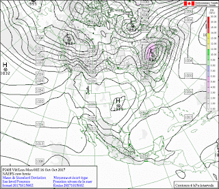
I don't normally do blocked weather on the NA-EFS. It tends to rectify to manoeuvre the linear dimensions out of right lines to either a zigzaged cross-hatch or a presentation of a right line consisting of three or more adjacent similar air masses.

But in this case the two cyclones to the west blocked by an anticyclone to the east develops unexpectedly well defines systems

Generally two lows like this will suck on the High and cause it to move out of line. It is unusual for this set up to remain as it does here, when over land

In this case the Lows appear to be losing definition to the Highs.

The discolouration shows the degree of uncertainty in the model. The NA-EFS forecast is notoriously short lived but as far as we can see (which is not more than three days if that) the western cyclone has sucked aq great deal of anticyclonic air into it.


Once the green appears I stop looking at the run, it has passed any certainty.

But it is still there. Until:

We have been shy of medium sized earthquakes for a few days now and I just heard Bogoslof blowing steam about a few hours ago.


Also look at the Hawaiian charts as they may be showing significant wet weather in the NE maybe even a Pineapple Express:

http://mkwc2.ifa.hawaii.edu/
This is not going to blow with a Superbang like Pinatubo or Mt St Helens. Which would you rather have, one huge eruption with a boom that goes around the world or this series of lots of little bangs. I fact during a volcanic series even the large bangs ar more like the medium ones.
Being first and foremost an oaf, Weatherlawyer was uninterested in mediocre bangs. Unless they went BOOM with both feet he always ignored them. I fact if you asked him why he was bothering now he might tell you:
Just to keep up momentum from the last blog posting.
Whereas in fact he was also hoping for some interesting developments but, hopefully, nothing deadly.
No comments:
Post a Comment