Interesting but wrong:
https://www.youtube.com/watch?v=silG6aIG9dw
Would you care to follow a volcanic eruption?
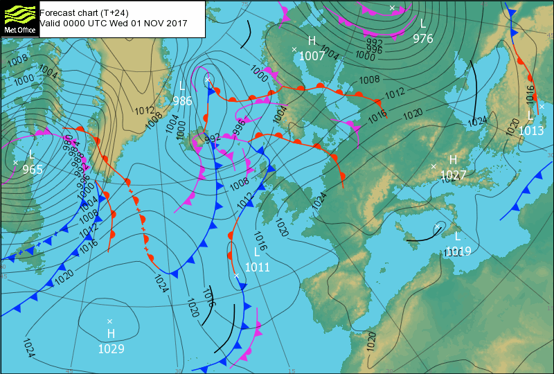
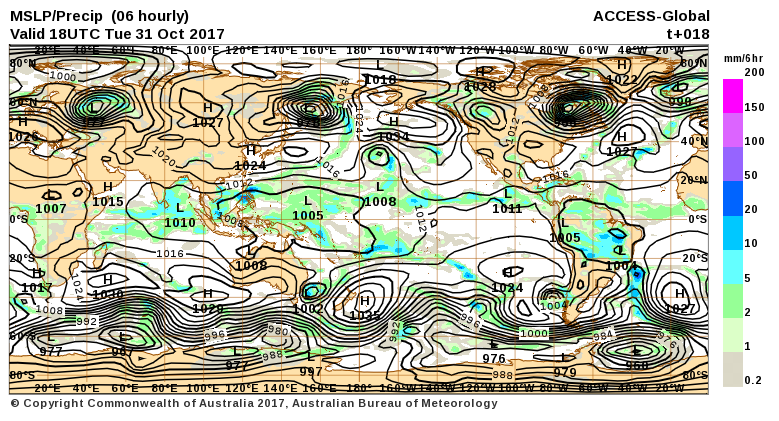
Day one was Monday the 30th. The NA-EFS farted and my only signal was a sustained hissing ring from tinnitus. However the weather broke with a nice sheet of overcast late this morning and so I eas inspired to collect most of the charts I had once collected. Here is what I saved:

The overcast landed as drizzle the faintest whisper of rain that has the impact of snow with wide margins barely anything to feel and nothing more to register than an ocaional fleck. But on the top of Hartshill there was not even that to know it.

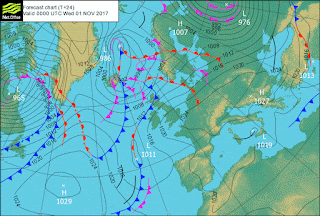


But here we have the first impression of yesterday's aftermath whatever it was. A large cyclone having withdrawn something from an adjacent one I suspect and two or three more exhausted ones below. A large earthquake set-up without proof of it.

Except that now it has all gone:
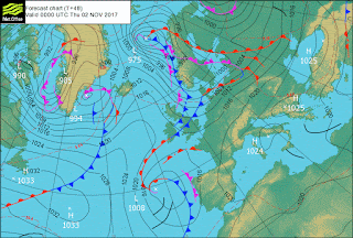
But line-outs are forming so more to come perhaps?


Some old cold storms working the system I dare say.
And these residual three cyclones?
What of them.


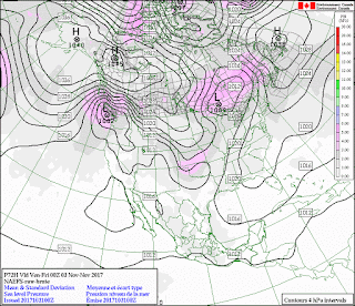
The northern hemisphere is a lot darker than the southern. Plenty of cold air down under:

Filling in time filling in time, I suspect.


I should collect the swarms but it can wait. You can all see where they are, just where you'd expect them to be (I dare say.)

So, not tornadoes yet.


I dare say you can wait?
You have no choice anyway.

If all goes well I should be able to follow through to the eruption and the multiplicity of polar points with their companion warm fronts.
Moon Apogee 00:14
There isn't much happening is there?
Volcanoes Today, 1 Nov 2017: Dukono volcano, Reventador, Sabancaya, Suwanose-jima
 Iris too:

I was hoping to see some tornadoes. I guess people got lucky:

It's possible.

Even likely.

But I had expected more. I suppose I should be grateful. It is easy to wish for things to go your way you without having to pay anything.
There is another line forming in the same place:

Looks like another bank of swarms.

https://www.youtube.com/watch?v=silG6aIG9dw
Would you care to follow a volcanic eruption?
Day one was Monday the 30th. The NA-EFS farted and my only signal was a sustained hissing ring from tinnitus. However the weather broke with a nice sheet of overcast late this morning and so I eas inspired to collect most of the charts I had once collected. Here is what I saved:

The overcast landed as drizzle the faintest whisper of rain that has the impact of snow with wide margins barely anything to feel and nothing more to register than an ocaional fleck. But on the top of Hartshill there was not even that to know it.


But here we have the first impression of yesterday's aftermath whatever it was. A large cyclone having withdrawn something from an adjacent one I suspect and two or three more exhausted ones below. A large earthquake set-up without proof of it.

Except that now it has all gone:

But line-outs are forming so more to come perhaps?


Some old cold storms working the system I dare say.
And these residual three cyclones?
What of them.


The northern hemisphere is a lot darker than the southern. Plenty of cold air down under:

Filling in time filling in time, I suspect.


I should collect the swarms but it can wait. You can all see where they are, just where you'd expect them to be (I dare say.)

So, not tornadoes yet.


I dare say you can wait?
You have no choice anyway.

If all goes well I should be able to follow through to the eruption and the multiplicity of polar points with their companion warm fronts.
Moon Apogee 00:14
There isn't much happening is there?
Volcanoes Today, 1 Nov 2017: Dukono volcano, Reventador, Sabancaya, Suwanose-jima


I was hoping to see some tornadoes. I guess people got lucky:
Wed, 1 Nov 2017, 22:00

It's possible.

Even likely.

But I had expected more. I suppose I should be grateful. It is easy to wish for things to go your way you without having to pay anything.
There is another line forming in the same place:

Looks like another bank of swarms.

time latitude longitude place mag magType C 2017-11-01T21:35:23.180Z 16.658 144.9293 85km WNW of Anatahan, Northern Mariana Islands 5 mb 2017-11-01T18:56:17.940Z -56.5197 -25.5453 103km E of Visokoi Island, South Georgia and the South Sandwich Islands 5 mb 2017-11-01T12:53:29.020Z -21.8452 168.7681 97km ESE of Tadine, New Caledonia 4.7 mb 2017-11-01T12:12:41.360Z -22.6394 25.0895 138km W of Moijabana, Botswana 4.7 mb 2017-11-01T11:27:30.830Z -21.8966 169.0347 125km ESE of Tadine, New Caledonia 4.5 mb 2017-11-01T09:33:46.450Z -21.7847 168.8002 98km ESE of Tadine, New Caledonia 5.4 mww 2017-11-01T08:46:21.790Z 12.7804 144.6039 54km S of Merizo Village, Guam 5 mb 2017-11-01T05:21:50.550Z -22.0372 169.0596 133km ESE of Tadine, New Caledonia 4.7 mb 2017-11-01T05:14:15.470Z -21.9142 169.2039 142km ESE of Tadine, New Caledonia 5.3 mb 2017-11-01T05:09:00.630Z -21.7928 168.9185 110km ESE of Tadine, New Caledonia 6 mww 2017-11-01T04:53:48.090Z -21.7046 169.351 152km E of Tadine, New Caledonia 4.9 mb 2017-11-01T04:19:19.620Z -21.5442 168.8648 101km E of Tadine, New Caledonia 4.5 mb 2017-11-01T04:13:21.950Z -21.555 168.6791 82km E of Tadine, New Caledonia 4.9 mb 2017-11-01T02:23:56.190Z -21.6302 168.8836 103km E of Tadine, New Caledonia 6.6 mww 2017-11-01T02:11:06.660Z -21.7828 168.9174 110km ESE of Tadine, New Caledonia 4.9 mb 2017-11-01T00:09:30.040Z -21.7145 168.9255 109km E of Tadine, New Caledonia 6.1 mww 2017-10-31T23:59:47.120Z -21.703 168.9225 108km E of Tadine, New Caledonia 5 mb 2017-10-31T23:18:05.120Z -7.3754 155.8921 109km SW of Chirovanga, Solomon Islands 5 mb 2017-10-31T23:06:04.110Z -21.6209 168.822 97km E of Tadine, New Caledonia 5.1 mb 2017-10-31T22:59:52.370Z -37.6252 177.3512 49km NE of Whakatane, New Zealand 5 mb 2017-10-31T22:50:16.450Z -21.7537 168.821 99km ESE of Tadine, New Caledonia 5.3 mww 2017-10-31T22:29:05.730Z -21.7262 168.8365 100km ESE of Tadine, New Caledonia 4.7 mb 2017-10-31T22:26:03.150Z -60.1029 -26.7335 119km S of Bristol Island, South Sandwich Islands 5.4 mb 2017-10-31T21:10:15.830Z -15.6996 -173.3072 54km ENE of Hihifo, Tonga 4.9 mb 2017-10-31T20:22:44.330Z -21.7719 168.9786 115km ESE of Tadine, New Caledonia 5 mb 2017-10-31T19:46:49.470Z -21.6068 168.8533 100km E of Tadine, New Caledonia 4.9 mwr 2017-10-31T19:41:16.220Z -21.7586 168.898 107km ESE of Tadine, New Caledonia 5.2 mww 2017-10-31T19:22:09.830Z -21.679 168.8173 97km E of Tadine, New Caledonia 5.4 mww 2017-10-31T18:24:36.600Z 2.0393 126.0698 118km NE of Bitung, Indonesia 5 mb 2017-10-31T16:47:48.090Z -3.8934 128.1176 18km S of Amahusu, Indonesia 5 mb 2017-10-31T16:30:30.170Z -15.7429 -173.1138 71km ENE of Hihifo, Tonga 5 mb 2017-10-31T15:25:19.970Z -21.5267 169.3155 148km E of Tadine, New Caledonia 4.6 mb 2017-10-31T13:52:21.530Z 34.9031 103.314 14km WNW of Qiagai, China 4.8 mb 2017-10-31T13:42:29.070Z -3.8236 127.6954 51km WSW of Hila, Indonesia 5.1 mb 2017-10-31T12:37:50.690Z -3.8124 127.8091 38km WSW of Amahusu, Indonesia 5.7 mww 2017-10-31T12:07:33.380Z 15.7775 -98.96 84km SSW of Tecoanapa, Mexico 4.8 mb 2017-10-31T11:50:51.980Z -3.7013 127.8157 32km WSW of Hila, Indonesia 6.3 mww 2017-10-31T11:34:44.460Z -3.8206 127.6642 53km WSW of Hila, Indonesia 5.7 mb 2017-10-31T11:31:42.810Z -3.7973 127.7212 47km WSW of Hila, Indonesia 5.9 mww 2017-10-31T07:36:06.450Z -37.5074 177.3491 59km NNE of Whakatane, New Zealand 5 mww 2017-10-31T05:03:44.020Z -8.716 118.8491 2km SSE of Rupe, Indonesia 4.9 mb 2017-10-31T04:58:58.120Z -15.5309 -173.3206 65km NE of Hihifo, Tonga 5.8 mb 2017-10-31T02:39:16.760Z -21.572 169.1886 135km E of Tadine, New Caledonia 5.1 mb 2017-10-31T02:20:46.420Z -21.4682 168.8953 105km E of Tadine, New Caledonia 5.9 mww 2017-10-31T01:40:10.180Z -21.566 169.2884 145km E of Tadine, New Caledonia 5 mb 2017-10-31T00:42:06.880Z -21.6598 169.2034 137km E of Tadine, New Caledonia 6.8 mww 2017-10-31T00:02:33.600Z 15.2476 -94.4366 106km SW of Paredon, Mexico 4.5 mb 2017-10-30T23:00:55.750Z 42.8255 146.5331 95km SE of Nemuro, Japan 4.6 mb 2017-10-30T22:37:19.230Z -8.6598 118.9454 7km SW of Lanta Timur, Indonesia 5.4 mb 2017-10-30T17:12:06.720Z -10.7359 -74.693 57km N of Satipo, Peru 5.7 mb 2017-10-30T16:21:39.030Z -7.4582 129.8333 172km WNW of Saumlaki, Indonesia 4.5 mb 2017-10-30T14:28:04.360Z 14.1456 -91.6549 33km ESE of Champerico, Guatemala 4.5 mb 2017-10-30T14:22:53.080Z -5.9895 146.3622 64km ENE of Kainantu, Papua New Guinea 4.9 mb 2017-10-30T12:54:28.060Z 20.2059 143.8524 115km WSW of Farallon de Pajaros, Northern Mariana Islands 4.6 mb 2017-10-30T12:14:33.520Z -5.5126 35.9178 60km NNW of Msanga, Tanzania 4.6 mb 2017-10-30T10:06:41.300Z 32.1672 141.7614 210km ESE of Hachijo-jima, Japan 4.9 mb 2017-10-30T06:42:41.240Z 14.2235 -91.9195 8km S of Champerico, Guatemala 4.5 mb 2017-10-30T06:16:26.540Z -55.9024 -27.3476 89km N of Visokoi Island, South Georgia and the South Sandwich Islands 4.9 mb 2017-10-30T05:13:59.740Z 15.3979 -94.3767 89km SW of Paredon, Mexico 4.9 mb 2017-10-30T04:09:09.830Z 67.716 142.7894 119km WSW of Druzhina, Russia 4.6 mb 2017-10-29T23:15:44.680Z 24.0759 122.3087 72km E of Hualian, Taiwan 4.9 mwr 2017-10-29T17:44:33.400Z 18.4774 -70.4917 8km S of San Jose de Ocoa, Dominican Republic 4.8 mb 2017-10-29T16:08:52.400Z -28.5947 -66.9767 17km W of Arauco, Argentina 4.5 mb 2017-10-29T15:35:13.930Z -5.5794 -106.713 Central East Pacific Rise 4.6 mb 2017-10-29T12:35:59.750Z 38.6472 144.4071 229km ESE of Kamaishi, Japan 4.6 mb 2017-10-29T11:16:30.770Z -13.1245 166.8118 115km NW of Sola, Vanuatu 4.7 mb 2017-10-29T06:21:45.420Z -15.0615 167.2991 26km E of Port-Olry, Vanuatu 4.9 mb 2017-10-29T04:05:33.970Z 1.5805 66.7787 Carlsberg Ridge 5.2 mb 2017-10-29T02:15:00.950Z -7.5468 130.4071 109km WNW of Saumlaki, Indonesia 4.6 mb 2017-10-28T19:11:01.690Z 86.8932 55.1348 North of Franz Josef Land 6 mww 2017-10-28T18:59:33.400Z 55.1889 -35.3131 Reykjanes Ridge 4.9 mb 2017-10-28T18:31:53.610Z 17.8536 -94.7305 6km ESE of Texistepec, Mexico 4.6 mb 2017-10-28T17:45:32.580Z 36.1978 70.6291 22km NW of `Alaqahdari-ye Kiran wa Munjan, Afghanistan 5.2 mww 2017-10-28T16:59:43.220Z -12.4147 -110.7346 Central East Pacific Rise 4.7 mb 2017-10-28T16:16:06.690Z 86.8922 52.8492 North of Franz Josef Land 5.8 mww 2017-10-28T16:13:54.440Z 86.8901 54.4953 North of Franz Josef Land 5.8 mww 2017-10-28T15:27:33.870Z -56.3414 147.2927 West of Macquarie Island 5.1 mb 2017-10-28T14:49:53.190Z 31.4287 129.0645 118km WSW of Kushikino, Japan 4.7 mb 2017-10-28T14:15:37.320Z -21.3949 -179.0627 90km SSW of Ndoi Island, Fiji 4.9 mb 2017-10-28T12:15:27.480Z -2.9196 140.6189 31km S of Abepura, Indonesia 4.7 mb 2017-10-28T11:31:26.880Z 16.4021 -97.5511 24km NW of San Miguel Panixtlahuaca, Mexico 4.6 mb 2017-10-28T08:25:03.540Z -56.7234 147.3847 West of Macquarie Island 5.3 mww 2017-10-28T06:27:50.180Z 13.3098 50.8856 160km N of Bereeda, Somalia 4.6 mb 2017-10-28T01:52:41.340Z -22.7612 -176.684 231km SW of Vaini, Tonga 4.6 mb 2017-10-27T17:52:03.770Z 16.7134 146.1291 63km NE of Anatahan, Northern Mariana Islands 5 mb 2017-10-27T12:34:33.970Z -20.7827 -175.2043 38km N of Nuku`alofa, Tonga 4.9 mb 2017-10-27T10:14:53.940Z 2.0596 96.5222 49km SSE of Sinabang, Indonesia 4.6 mb 2017-10-27T09:38:39.990Z 45.6355 150.9914 247km ENE of Kuril'sk, Russia 4.9 mb 2017-10-27T06:34:48.000Z -31.9702 -176.4202 242km ESE of L'Esperance Rock, New Zealand 4.6 mb 2017-10-27T03:49:35.380Z -4.6059 149.6067 120km NNW of Kimbe, Papua New Guinea 4.5 mb 2017-10-27T03:48:29.960Z -8.4533 -79.8617 87km SW of Santiago de Cao, Peru 4.7 mb 2017-10-27T00:16:43.480Z 64.6095 -18.0017 119km S of Akureyri, Iceland 4.6 mb 2017-10-26T23:26:35.700Z 64.6426 -17.5591 118km SSE of Akureyri, Iceland 4.6 mb 2017-10-26T19:29:22.390Z -3.7205 151.1617 123km WNW of Rabaul, Papua New Guinea 4.7 mb 2017-10-26T17:32:46.660Z -5.2606 145.6244 19km WSW of Madang, Papua New Guinea 4.9 mb 2017-10-26T17:16:59.380Z 24.9846 127.9768 130km SSE of Itoman, Japan 4.7 mb 2017-10-26T16:26:20.310Z 53.992 128.5289 87km ENE of Zeya, Russia 4.7 mb 2017-10-26T07:59:30.250Z 10.1412 -73.5727 38km WNW of Agustin Codazzi, Colombia 4.8 mb 2017-10-26T00:13:53.020Z 55.4388 163.2662 100km SSE of Ust'-Kamchatsk Staryy, Russia 4.5 mb
Recall that the sequences of Magnitudes are dropped at least one point when the cycle is volcanic. |