The heavens declare the glory of God, and the sky proclaims the work of his hands. Psalm 19, God doesn't conceal anything nothing created is ever made in secret and that is why you must have confidence that everything he gives us, he is telling us all about it.
I am going to relate the sequences of a volcanic eruption following an Atlantic storm and ask you to look out for the things in the sequence where he "tells"us what where and when.
Note he does not tell us how. We have to demonstrate to him that we are not beasts by understanding how.
Then God said, "Let us make mankind in our image, in our likeness, so that they may rule over the fish in the sea and the birds in the sky, over the livestock and all the wild animals, and over all the creatures that move along the ground."
Yes, I am religious but how can you possibly study geo-physics and not identify in each phase the complete control god has over his designs?
It would be a wondrous lack of imagination to think that it could have a ceaseless repetition without laws of engineering.
The sequences for volcanic eruptions following a tropical storm is:
The storm peaks and enters Cyclosis.
As the Beaufort Numbers drop, a number of small earthquakes appear that follow a regular pattern around the eye of the storm. This pattern isusually some 80 degrees distant from the storm track's eye en route especially at each stage where the Beaufort number has fallen.
A scream can be heard by people who have tinnitus at the same time as vapour is released from the crater and a low cloud soon forms over parts of Europe. The extent of the cloud depends on its origin and the initial strength of the storms involved.
The recent and ongoing events in the Atlantic produced precipitation in Britain that is noteworthy:
https://groups.google.com/forum/?hl=en-GB#!topic/uk.sci.weather/I87EgETarcw
https://groups.google.com/forum/?hl=en-GB#!topic/uk.sci.weather/_3hfl5RIUfU
(By and large, the experts here are each duller than a half dozen plank stumps, however one or two of them occasionally emit radiation (although without dazzle.))
The day after this mist clears the number of cyclonic (and anticyclonic) eyes doubles.
(It is Thursday 27 September 2017 and yesterday was the second day of overcast. This afternoon the sky began to clear and now it is dark but it is a fine day, so there will be about 12 or so Polar Points out in the North Atlantic tomorrow signifying the sunniest day of this spell.
The exact number of Lows and Hight is governed by the extent of the Greenland High. These polar points indicate warm sunny days in high summer ans cold frosty ones in midwinter. An explanation for record temperatures as if one were needed.
Maybe some half competent geo-meteorologist will manage to get his head around this phenomena and submit a study of the factors involved to a research group. If you want my opinion I will be long dead before that happens.
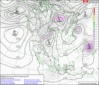
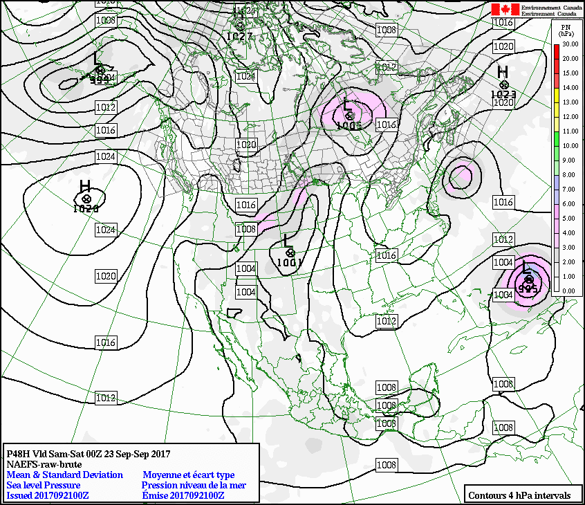
In North America the Sea Level Pressure Charts indicate the regions and directions of the next eruptions. The charts to use are the NA-EFS:
https://weather.gc.ca/ensemble/naefs/cartes_e.html
On days when they lack clarity:

Just cycle ahead a few says and interpolate try and work it out Algebraically.
I actually wore all this by hand yesterday and it has taken me to now 10:30 pm to transcribe it to the blog, I'm two thirds of the way through, -that is how difficult things are for me now. I will soon be looking forwards to shaking loose my shackles to this earth and I'm already curious about what comes next.
The indications for eruptions are as follows:
1. A straight line of cyclones stretching across Canada from West to East is (at the moment) Bogoslof erupting. Other volcanoes on the Aleutian arc may offer the same forecast
2. Lines of anticyclone presage eruptions on the other side of the globe from
3. Whatever angles the runs of straight lines make indicate the region of eruptive activity. North America (Europe and Africa to Indonesia.)
4. Sometimes the charts show tropical storms or tornadic events with the "opposite" of alignments; in this case the charts show alternating highs and lows zigzagging and blocking one another.
On these occasions look out for more activity.
There is a great deal of information about geo-phenomena that is revealed in the charts of the oceans. I have done my best to wake you to them but I have merely touched in this outline what could be said.
I am exhausted for the moment. I would like to take you through the charts of the Southern Ocean but that must wait for tomorrow.
I am going to relate the sequences of a volcanic eruption following an Atlantic storm and ask you to look out for the things in the sequence where he "tells"us what where and when.
Note he does not tell us how. We have to demonstrate to him that we are not beasts by understanding how.
Then God said, "Let us make mankind in our image, in our likeness, so that they may rule over the fish in the sea and the birds in the sky, over the livestock and all the wild animals, and over all the creatures that move along the ground."
Yes, I am religious but how can you possibly study geo-physics and not identify in each phase the complete control god has over his designs?
It would be a wondrous lack of imagination to think that it could have a ceaseless repetition without laws of engineering.
The sequences for volcanic eruptions following a tropical storm is:
The storm peaks and enters Cyclosis.
As the Beaufort Numbers drop, a number of small earthquakes appear that follow a regular pattern around the eye of the storm. This pattern isusually some 80 degrees distant from the storm track's eye en route especially at each stage where the Beaufort number has fallen.
A scream can be heard by people who have tinnitus at the same time as vapour is released from the crater and a low cloud soon forms over parts of Europe. The extent of the cloud depends on its origin and the initial strength of the storms involved.
The recent and ongoing events in the Atlantic produced precipitation in Britain that is noteworthy:
https://groups.google.com/forum/?hl=en-GB#!topic/uk.sci.weather/I87EgETarcw
https://groups.google.com/forum/?hl=en-GB#!topic/uk.sci.weather/_3hfl5RIUfU
(By and large, the experts here are each duller than a half dozen plank stumps, however one or two of them occasionally emit radiation (although without dazzle.))
The day after this mist clears the number of cyclonic (and anticyclonic) eyes doubles.
(It is Thursday 27 September 2017 and yesterday was the second day of overcast. This afternoon the sky began to clear and now it is dark but it is a fine day, so there will be about 12 or so Polar Points out in the North Atlantic tomorrow signifying the sunniest day of this spell.
The exact number of Lows and Hight is governed by the extent of the Greenland High. These polar points indicate warm sunny days in high summer ans cold frosty ones in midwinter. An explanation for record temperatures as if one were needed.
Maybe some half competent geo-meteorologist will manage to get his head around this phenomena and submit a study of the factors involved to a research group. If you want my opinion I will be long dead before that happens.
In North America the Sea Level Pressure Charts indicate the regions and directions of the next eruptions. The charts to use are the NA-EFS:
https://weather.gc.ca/ensemble/naefs/cartes_e.html
On days when they lack clarity:

Just cycle ahead a few says and interpolate try and work it out Algebraically.
I actually wore all this by hand yesterday and it has taken me to now 10:30 pm to transcribe it to the blog, I'm two thirds of the way through, -that is how difficult things are for me now. I will soon be looking forwards to shaking loose my shackles to this earth and I'm already curious about what comes next.
The indications for eruptions are as follows:
1. A straight line of cyclones stretching across Canada from West to East is (at the moment) Bogoslof erupting. Other volcanoes on the Aleutian arc may offer the same forecast
2. Lines of anticyclone presage eruptions on the other side of the globe from
3. Whatever angles the runs of straight lines make indicate the region of eruptive activity. North America (Europe and Africa to Indonesia.)
4. Sometimes the charts show tropical storms or tornadic events with the "opposite" of alignments; in this case the charts show alternating highs and lows zigzagging and blocking one another.
On these occasions look out for more activity.
There is a great deal of information about geo-phenomena that is revealed in the charts of the oceans. I have done my best to wake you to them but I have merely touched in this outline what could be said.
I am exhausted for the moment. I would like to take you through the charts of the Southern Ocean but that must wait for tomorrow.
No comments:
Post a Comment