http://mkwc2.ifa.hawaii.edu/models/modelsanim.cgi?model=gfs&domain=npac¶m=winds&orient=horiz&level=sfc&modeltime=2017092506&gfsanimduration=384&banner=mkwc&imgsize=med&animtype=flash
I say this with my tongue in my mouth.
Seriously!
When the charts screw up there is generally something important that they are not telling us. By coincidence, I have been teaching you to read between the lines.
Please do so
Speaking of charts screwing up I have just lost this blog. Now is the chance to start again with a description of the North Atlantic in a volcanic eruption:

A lot of overcast in my town (a noted fog-bank in the bad old days.) Note the separated fronts. Warm to the north where their higher energy takes them into the Arctic. Cold fronts go east to the storehouse of war.

When it gets to look busy beware.

Keep a eye on the Greenland/Icelandic Low

And the short ends of the warmth

These will give way to a Greenland High with a warm couple of days and sunny weather.

Count how many cyclones and anticyclones you see.
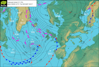
But don't forget the storehouses for snow in the day of war. And be extra careful.

But unfortunately I was too upset with Google to refrain from bad language. Try again with a little less but well deserved invective. This too must pas.
No comments:
Post a Comment