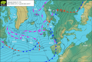
This looks like there might be a repercussion from the recent terror weapon's use. Whatever the case the fronts appearing on these charts are interesting:
5.7M. 249km NNE of Chichi-shima, Japan 21December 2017 03:00 (UTC) that's five days ago! Take care.
The delta front coming out of this is a classic Tornadic set up if it passes between two anticyclones they will produce an horrendous amount of damage.
It looks like it does and it is over a large area.
***
Hang in with this stuff as there is a blocking high operating on the Rockies at the moment that should not be there so when it breaks -at perhaps the new moon on the 28th? it will clear the air.
There is far too much warmth on here to allow any air to escape into the arctic, maybe the angels are hanging on to it for us. Paying back stoopid for trying to ruin god's footstool for man.
Make no mistake! God is looking after us.
I still can't see it happening.
Maybe this is it?
Watch the development of the T+120 chart over these next few days. T+120 is five days out. From noon on the 25th. that means the phenomenon has been held in abeyance for something like a full 2 days and it still doesn't give a clear signal.
I should be watching for contiguous Lows or Highs running in a straight line most likely with these two laqrge Lows on the first chart.
The NA-ES is not very good for long ranges over three days.
But here they are anyway:
Another 5 days but I am sure the Lows will have blown an hole through the block before then.
The American chart. I wonder why they don't do a 5 day run?
Scared?
And the suction in the North Paciic from the Australians, my second favourite sites. The air in the Arctic is supercooled with all the circulation and recirculation up there. Makea bigga banga BOOOM!
You can see the air is still too warm for our own good.
We had best never do this again!
The Antarctic Isobars tell a tale about continued Volcanic shock-waves.
And this is a picture of missing above-magnitude 5.5Ms.


No comments:
Post a Comment