In September 2017, the area experienced 844 volcanic earthquakes, peaking at 300 to 400 earthquakes on 26 September. The frequency and intensity of these quakes caused much alarm among seismologists, as similar volcanoes have historically been known to erupt with even fewer warning signs.
In late September, as a result of the increased rumbling and seismic activity around the volcano, the alert level was raised to the highest level and about 122,500 people were evacuated from their houses around the volcano. The Indonesian National Disaster Management Authority declared a 12-kilometer exclusion zone around the volcano on September 24.
Evacuees gathered in sports halls and other community buildings around Klungkung, Karangasem, Buleleng, and other areas. The monitoring station is located in Tembuku, Rendang, Karangasem Regency, from which the intensity and frequency of tremors were closely monitored for signs of imminent eruption.
By late October 2017, the activity of the volcano decreased significantly, leading to lowering of the highest status of emergency on October 29.
On 21 November, activity increased once again. A phreatic eruption took place, with the ash cloud top reaching 3,842 metres (12,605 ft) above sea level. Thousands of people immediately fled the area, and over 29,000 temporary refugees were reported to be housed in over 270 locations nearby.
Early on Saturday 25 November a magmatic eruption began. The resulting eruption plume was reported to rise about 1.5-4 km above the summit crater, drifting towards the south and dusting the surroundings with thin layer of dark ash, leading some airlines to cancel flights bound for Australia and New Zealand.
An orange glow was later observed around the crater at night, suggesting that fresh magma had indeed reached the surface. On 23:37, 26 November 2017 (GMT), another eruption occurred, the second in less than a week. Ngurah Rai International Airport was closed 26 November, 2017, leaving many tourists stranded.
Lahars were reported in the Selat district south of the volcano. More than 100,000 people in a 10 km (6 mi) radius of the volcano were ordered to evacuate. Australia's Bureau of Meteorology reported on 27 November that ash from the eruption had been observed at an altitude of 9,144 m.
So far, the eruption seems to be VEI 2 on Volcanic Explosivity Index. Type of the eruption is Vulcanian or Sub-plinian.
On 27 November the Indonesian National Disaster Management Authority announced that the level of alert had been raised from Level 3 (Siaga, or Alert) to Level 4 (Awas, or Warning), the highest official warning level, as from 6.00 am on 27 November. At the same time, a general warning was issued for all persons to refrain from any activity of any kind in the Estimated Danger Zone (Zona Perkiraan Bahaya) located within 8 km of the crater of Gunung Agung and, as well, in the wider sectoral area in the northeast region towards the sea and the south and southeastern hinterland of the mountain out to 10 km from the crater.
In the beginning of December, the eruption powered down to minor emissions of steam and smoke. There are no reports of new volcanic ash on ground.
Agung | Bali (Indonesia) | 8.343°S, 115.508°E | Summit elev. 2997 m
PVMBG reported that at 1730 on 25 November, after the number of volcanic earthquakes significantly increased, ash plumes rose 1.5 km above Agung’s crater rim and drifted 12 km WSW. Ashfall was reported in areas SW including Besakih (7 km SW), hamlets in the upper part of Pempatan (7.5 km W), and Temukus, prompting remaining residents to evacuate to the S. Eight inbound and 13 outbound international flights were cancelled, affecting 2,087 passengers. Crater incandescence was observed at 2100, signifying the presence of lava in the crater. BNPB noted that the number of evacuees was 25,016 (spread out in 224 shelters)
On 26 November dark gray ash plumes rose 2 km at 0505, 3 km at 0545, and 4 km at 0620, and drifted E and SE. Ash emissions continued throughout the day; a few explosions were heard within a 12-km radius. PVMBG issued a Volcano Observatory Notice for Aviation (VONA) elevating the Aviation Color Code from Orange to Red.
Satellite data recorded sulfur dioxide gas concentrations ranging from 1,000 to 2,000 tons/day. Ashfall was reported in several areas downwind including North Duda (9 km S), Duda Timur (12 km S), Pempetan, Besakih, Sideman (15 km SSW), Tirta Abang, Sebudi (6 km SW), Amerta Bhuana (10 km SSW) in Klungkung, and some villages in Gianyar (20 km WSW). Ashfall was the thickest (5 mm) in Sibetan (11.5 km S). News sources noted that Lombok International Airport closed during 26-27 November.
PVMBG raised the Alert Level to 4 (the highest level on a scale of 1-4) on 27 November, and the exclusion zones were expanded to a general 8-km radius and to 10 km in the NNE, SE, S, and SW directions. Dense ash plumes continued to rise 2-4 km above the crater rim. Based on satellite data, the Darwin VAAC reported that ash plumes rose as high as 9.1 km (30,000 ft) a.s.l., or just over 6 km above the crater rim. Pictures and video showed a white steam plume adjacent to a gray ash plume rising form the crater, signifying two distinct active vents.
According to news articles the Ngurah Rai International Airport in Bali closed due to the airborne ash. On 28 November BNPB noted that the number of evacuees had increased to 38,678, and were distributed in 225 evacuation centers. The Ngurah Rai International Airport reopened on 29 November, after the Aviation Color Code was lowered to Orange.
PVMBG reported that the eruption at Agung, which began on 21 November, continued during 30 November-5 December. On 29 November gray ash plumes levels were rising to 2 km above the crater rim, resulting in ashfall to the SE. During 30 November-5 December emissions continued to rise 2 km; most were white in color, but dense gray ash emissions were noted during 1-2 December.
Satellite data indicated that lava effusion continued at least through 1 December, and the erupted volume of lava was estimated to be 20 million cubic meters, equivalent to about a third of the total crater volume. The base of the plume was often reddish during 29 November-5 December reflecting incandescence from lava in the crater. BNPB noted on 5 December that 63,885 evacuees were distributed in 225 evacuation shelters.
Lahars were first noted on 21 November and continued to be observed through 5 December. The lahars flowed down drainages on the S flank (along the Tukad Yehsa, Tukad Sabuh, and Tukad Beliaung drainages) and also down the Tukad Bara drainage on the N flank, impacting houses, roads, and agricultural areas. The Alert Level remained at 4 (on a scale of 1-4), and the exclusion zones continued at a general 8-km radius and 10 km in the NNE, SE, S, and SW directions.

I don't have the ability to concentrate like I used to. And I can't find a decent computer fire that allows me to see the behaviour of the Inner Planets unless I concentrate. It is 08:45 and I am timing myself with reproducing one frame at a time as above.
20 minutes. What was all the fuss besides the fact I made one or two errors?
In late September, as a result of the increased rumbling and seismic activity around the volcano, the alert level was raised to the highest level and about 122,500 people were evacuated from their houses around the volcano. The Indonesian National Disaster Management Authority declared a 12-kilometer exclusion zone around the volcano on September 24.
Evacuees gathered in sports halls and other community buildings around Klungkung, Karangasem, Buleleng, and other areas. The monitoring station is located in Tembuku, Rendang, Karangasem Regency, from which the intensity and frequency of tremors were closely monitored for signs of imminent eruption.
By late October 2017, the activity of the volcano decreased significantly, leading to lowering of the highest status of emergency on October 29.
On 21 November, activity increased once again. A phreatic eruption took place, with the ash cloud top reaching 3,842 metres (12,605 ft) above sea level. Thousands of people immediately fled the area, and over 29,000 temporary refugees were reported to be housed in over 270 locations nearby.
Early on Saturday 25 November a magmatic eruption began. The resulting eruption plume was reported to rise about 1.5-4 km above the summit crater, drifting towards the south and dusting the surroundings with thin layer of dark ash, leading some airlines to cancel flights bound for Australia and New Zealand.
An orange glow was later observed around the crater at night, suggesting that fresh magma had indeed reached the surface. On 23:37, 26 November 2017 (GMT), another eruption occurred, the second in less than a week. Ngurah Rai International Airport was closed 26 November, 2017, leaving many tourists stranded.
Lahars were reported in the Selat district south of the volcano. More than 100,000 people in a 10 km (6 mi) radius of the volcano were ordered to evacuate. Australia's Bureau of Meteorology reported on 27 November that ash from the eruption had been observed at an altitude of 9,144 m.
So far, the eruption seems to be VEI 2 on Volcanic Explosivity Index. Type of the eruption is Vulcanian or Sub-plinian.
On 27 November the Indonesian National Disaster Management Authority announced that the level of alert had been raised from Level 3 (Siaga, or Alert) to Level 4 (Awas, or Warning), the highest official warning level, as from 6.00 am on 27 November. At the same time, a general warning was issued for all persons to refrain from any activity of any kind in the Estimated Danger Zone (Zona Perkiraan Bahaya) located within 8 km of the crater of Gunung Agung and, as well, in the wider sectoral area in the northeast region towards the sea and the south and southeastern hinterland of the mountain out to 10 km from the crater.
In the beginning of December, the eruption powered down to minor emissions of steam and smoke. There are no reports of new volcanic ash on ground.
Agung | Bali (Indonesia) | 8.343°S, 115.508°E | Summit elev. 2997 m
PVMBG reported that at 1730 on 25 November, after the number of volcanic earthquakes significantly increased, ash plumes rose 1.5 km above Agung’s crater rim and drifted 12 km WSW. Ashfall was reported in areas SW including Besakih (7 km SW), hamlets in the upper part of Pempatan (7.5 km W), and Temukus, prompting remaining residents to evacuate to the S. Eight inbound and 13 outbound international flights were cancelled, affecting 2,087 passengers. Crater incandescence was observed at 2100, signifying the presence of lava in the crater. BNPB noted that the number of evacuees was 25,016 (spread out in 224 shelters)
On 26 November dark gray ash plumes rose 2 km at 0505, 3 km at 0545, and 4 km at 0620, and drifted E and SE. Ash emissions continued throughout the day; a few explosions were heard within a 12-km radius. PVMBG issued a Volcano Observatory Notice for Aviation (VONA) elevating the Aviation Color Code from Orange to Red.
Satellite data recorded sulfur dioxide gas concentrations ranging from 1,000 to 2,000 tons/day. Ashfall was reported in several areas downwind including North Duda (9 km S), Duda Timur (12 km S), Pempetan, Besakih, Sideman (15 km SSW), Tirta Abang, Sebudi (6 km SW), Amerta Bhuana (10 km SSW) in Klungkung, and some villages in Gianyar (20 km WSW). Ashfall was the thickest (5 mm) in Sibetan (11.5 km S). News sources noted that Lombok International Airport closed during 26-27 November.
PVMBG raised the Alert Level to 4 (the highest level on a scale of 1-4) on 27 November, and the exclusion zones were expanded to a general 8-km radius and to 10 km in the NNE, SE, S, and SW directions. Dense ash plumes continued to rise 2-4 km above the crater rim. Based on satellite data, the Darwin VAAC reported that ash plumes rose as high as 9.1 km (30,000 ft) a.s.l., or just over 6 km above the crater rim. Pictures and video showed a white steam plume adjacent to a gray ash plume rising form the crater, signifying two distinct active vents.
According to news articles the Ngurah Rai International Airport in Bali closed due to the airborne ash. On 28 November BNPB noted that the number of evacuees had increased to 38,678, and were distributed in 225 evacuation centers. The Ngurah Rai International Airport reopened on 29 November, after the Aviation Color Code was lowered to Orange.
PVMBG reported that the eruption at Agung, which began on 21 November, continued during 30 November-5 December. On 29 November gray ash plumes levels were rising to 2 km above the crater rim, resulting in ashfall to the SE. During 30 November-5 December emissions continued to rise 2 km; most were white in color, but dense gray ash emissions were noted during 1-2 December.
Satellite data indicated that lava effusion continued at least through 1 December, and the erupted volume of lava was estimated to be 20 million cubic meters, equivalent to about a third of the total crater volume. The base of the plume was often reddish during 29 November-5 December reflecting incandescence from lava in the crater. BNPB noted on 5 December that 63,885 evacuees were distributed in 225 evacuation shelters.
Lahars were first noted on 21 November and continued to be observed through 5 December. The lahars flowed down drainages on the S flank (along the Tukad Yehsa, Tukad Sabuh, and Tukad Beliaung drainages) and also down the Tukad Bara drainage on the N flank, impacting houses, roads, and agricultural areas. The Alert Level remained at 4 (on a scale of 1-4), and the exclusion zones continued at a general 8-km radius and 10 km in the NNE, SE, S, and SW directions.
November 2017

I don't have the ability to concentrate like I used to. And I can't find a decent computer fire that allows me to see the behaviour of the Inner Planets unless I concentrate. It is 08:45 and I am timing myself with reproducing one frame at a time as above.
20 minutes. What was all the fuss besides the fact I made one or two errors?
December 2017


Now to stitch them together. I should be grateful that I live in the age of the computer. And I am I am only grateful to Formilab for producing this relic from Windows 98 in all its glory and allowing me to do so much with it one frame at a time. The least said about my exploits with Celestia or what the **** it's called the better.
Good luck with your startrek fandom.
But on with the show. There is a reason for all this. I just have to work out what it is...

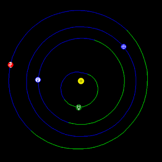
Notice how slowly Mars travels in all of this. Imagine how little change there is with the other outer planets. Do you suppose their impact is immaterial.
Note the distances Mercury reaches. There is an almost undetectable blip as it approaches the sun. It it possible to detect how much the presence of the earth affects its alignment. I can't tell if Mercury slows or accelerates.
Time for a break with reality, children, you can piss off and play Star Trek if you like or if you want to be depressed you can watch the BBC brainwash/fake media while I apologise to the British coal miners for what I allowed Margaret Thatcher to do to you while your children starved.
https://www.youtube.com/watch?v=AgyWhdSe0Yc
Or here is another one about the Americans doing the job it's own government wanted to prevent anyone/everyone doing:
https://www.youtube.com/watch?v=AgyWhdSe0Yc
With a bit of luck Google will make this difficult to open with a click. So I will just go ahead and play with what I can. Not that I am accusing them of fake news. I don't need to. Everyone else that can also think, does it already.
How the hell did this get six views before I even posted it?
It must be hot linked to the FIB, CIA, GCHQ and dupicated. Good, let the bastards see we are coming for them!
How the hell did this get six views before I even posted it?
It must be hot linked to the FIB, CIA, GCHQ and dupicated. Good, let the bastards see we are coming for them!
No comments:
Post a Comment